Updates are added on top .. Earlier posts are pushed down.
( Upadte 91Mar2017/ 3 AM IST )
There were 4 rocket launches in the month February 2017.

They carried 112 satellites to space.
104 out of these 112 were carried in a single flight, PSLV C37 !!!
( Upadte 22Feb/10 AM IST )
Here is what I feel is the orientation changes of Launch Capsule during release of satellites based on the real-time video.

Below, On left is reproduced an image posted earlier showing the photograph of Launch Capsule ( 4th stage ) captured from the PSLV C37 assembly video.
It is superimposed with the symbol that we will use in this post.
Little Red square is the location of camera that shows the release of Cartosat 2D and INS 1A and INS 1B.
Blue and Yellow represent P+ and P- cameras respectively.

The symbol is superimposed on the launch geometry posted earlier showing the orientation of Launch Assembly in 3 orientations along the PSLV C37 launch path.
 Only the Launch Capsule is shown on Right.
Vehicle started from SHAR and brought the capsule in the position shown on top .. the Orange cylinder is the 4th stage engine pointed backwards. Within about 40 seconds after the PS4 shutdown the capsule is rotated so that the satellites which are attached to this assembly are facing backwards. alsothe capsule is rolled 1/4 th turn so that the Red square camera is now on 'left' of the path.
Cartosat and INS satellites are released in this position but in the video it appears that the satellites are released while the camera is on the 'TOP' surface of satellite. It is not so. The arc of Earth in the background is actually the Eastern edge illuminated with morning Sunlight.
( Upadte 17Feb/10 AM IST )
Here are some graphics showing the Geographical location where the satellites were released.
 Here the light blue running North-South shows the intended orbit in which the satellites were to be released, An earlier post ( 10 Feb ) shows how the PSLV C37 rises from SHAR ( Sriharikota ) to this orbit.
Figure on left shows various Receiving and Control stations involved during this launch. They are : SHAR, Thiruvananthpuram ( TVM ), Port Blair, Mauritius and a Norwegian station at South Pole ( TROLL ).
Every station has a limit of its visibility. It can,t communicate beyond this boundary due to the curvature of Earth's sphere which is shown by the circles around each station witha radius of about 2700 Kms.
Notice that from launch to the point marked as C37, The rocket is visible to at least one station. But at that point the orbit goes beyond the visibility of MAU station and is not visible to any station till it reaches near South pole.
If you had seen the live coverage you may remember that for about 6 minutes all the people in control room were just sitting anxiously but doing nothing. Actually the real satellite launch activity was going on at that time ( almost 80 satellites were released in that period ) but there was no communication from the vehicle that all satellites were released correctly because there was no communication between the vehicle and control room.
Only after the vehicle entered visibility of TROLL did they know that 'all is well' and we could see their gloomy faces turning into satisfactory grin.

The region where these satellites were released is shown in the figure on Right.
( Upadte 15Feb/8PM IST )
Early today morning ( 0358 UT/ 0928 IST ) PSLV C37 rocket was ignited and it faultlessly entered the intended orbit of 505Kms/97.5deg inclination after 16 minutes of powered flight.
After a minute it released 3 Indian Satellites viz Cartosat 2D, INS 1A and INS 1B.
After another minute it started hurling out the 101 NanoSats for next 10 minutes.
In between for 6 minutes there was a silence period because the launcher was not visible to any receive station on Earth. ( It went out of visibility range of Mauritius station and came into visibility of Antarctic Station of India 6 minutes later ). However the satellite launch was continuing during this period also. Confirmation of these launches was received only after Antarctica station received the telemetry. ( A HOLD YOUR BREATH period of anxiety).
ISRO also had mounted several good cameras ( unlike in the earlier mission ) onbord and it released the footage later.
Here is the grab form that video:
New stars appear in the sky!!!
These are just a part of the flock of satellites being released by PSLV C37 which released 104 satellites in one go forming a starry appearance in the dark sky near the Satellite Housing .
Image is a grab from ONBOARD camera video footage released by ISRO.
Watch the video ( http://isro.gov.in/…/15-feb-2017/pslv-c37-lift-and-onboard-…) and enjoy the floating and spinning of so many birds in space at a height of 500+ kms above ground.

It is breathtaking!!!!! ....some being released from top side and some appearing from bottom side seen over Earth surface. Notice the Edge of Earth on right side of next image.

===================== ======================= =======================
( Update : 14Feb/ 9 PM IST )

A grab from Integration video showing the assembly of Satellite Bay
Satellite identification is my interpretation .. not official version
=================== ===================== ================== =============
( Update : 10Feb/ 11AM IST )

Based on the warning to air-traffic at Chennai airport, a graphic showing the path of the rocket is drawn on Right.
Left part shows the path as seen from top while the right hand part shows the altitude aspect
Notice how the rocket avoids Srilanka by going around it to avoid the falling debris to cause harm to land based area.
This turning around is popularly known as " Dog Leg Maneuver" .
16.5 minutes after ignition the rocket attains its intended orbit of 510 Kms and The 1st satellite to be released 17.5 minutes after the rocket ignition is Cartosat 2D, followed immediately by the remaining 2 Indian satellites INS 1A and INS 1B.
A minute later the release of other satellites starts and all of those are released in next 10 minutes thus achieving the record launch of 104 satellites in a single flight.
=================== ======================= ================= ============
First post:
Just like Indian Cricket team, ISRO is set to make a record of attaining a century this month.
In fact it is set to launch 104 - yes, you read it right 1 0 4 - satellites during a single flight on Feb 15th using a PSLV rocket in its C37 flight.
Interestingly there are only 3 Indian satellites on this flight :
- Cartosat-2D
- INS-1A
- INS-1B.
( The 3 weigh 639kg + 13KG + 13Kg )
Rest 101 are very small satellites ( Generally called Nano Satellites due to their miniature size and light weight. ) from US ( 96 Sats ), Israel ( 2 Sats ), Kazakistan, UAE and Netherlands ( 1 Sat each ).
These 101 satellites weigh about 500 Kgs.
- 88 satellites are DOVE satellites of PLANET, a US based company involved in Earth Imaging Services. ( They already have 12 DOVEs in operation .. now with 88 new sats they will have 100!!!! ). All mind boggling numbers!!
Most of the non-ISRO satellites are being co-ordinated by a Netherlands entity, ISIS – Innovative Solutions In Space - which has pioneered as a nano-satellite developer and mission operator.
They have developed a four satellite container called QuadPack which holds the 4 satellites till the QuadPack is launched by the rocket and releases them later independently.
We can speculate that there may be 25 QuadPacks aboard PSLV C37 arranged around the 3 large Indian Satellites. ( A Crowdy environment .. isn't it ?? ).
BTW, ISRO is expected to recover about half of Launch Cost from these satellite operators for launching these satellites.
While we await the official document about the launch from ISRO an interesting question has been raised in one of the discussion forum:
What if one of those 88 sats are programmed to explode thus causing the loss of Cartosat & crush PSLV image in the market?
We know that any launch vehicle operator will test the satellite thoroughly before being integrated with the rocket, the possibility can't be denied totally.
What re your views? Please tell in the comments section .. I am sure it is an interesting question and we could have some lively discussion here !!
( Upadte 91Mar2017/ 3 AM IST )
There were 4 rocket launches in the month February 2017.

They carried 112 satellites to space.
104 out of these 112 were carried in a single flight, PSLV C37 !!!
( Upadte 22Feb/10 AM IST )
Here is what I feel is the orientation changes of Launch Capsule during release of satellites based on the real-time video.

Below, On left is reproduced an image posted earlier showing the photograph of Launch Capsule ( 4th stage ) captured from the PSLV C37 assembly video.
It is superimposed with the symbol that we will use in this post.
Little Red square is the location of camera that shows the release of Cartosat 2D and INS 1A and INS 1B.
Blue and Yellow represent P+ and P- cameras respectively.

The symbol is superimposed on the launch geometry posted earlier showing the orientation of Launch Assembly in 3 orientations along the PSLV C37 launch path.
Vehicle started from SHAR and brought the capsule in the position shown on top .. the Orange cylinder is the 4th stage engine pointed backwards. Within about 40 seconds after the PS4 shutdown the capsule is rotated so that the satellites which are attached to this assembly are facing backwards. alsothe capsule is rolled 1/4 th turn so that the Red square camera is now on 'left' of the path.
Cartosat and INS satellites are released in this position but in the video it appears that the satellites are released while the camera is on the 'TOP' surface of satellite. It is not so. The arc of Earth in the background is actually the Eastern edge illuminated with morning Sunlight.
( Upadte 17Feb/10 AM IST )
Here are some graphics showing the Geographical location where the satellites were released.

Figure on left shows various Receiving and Control stations involved during this launch. They are : SHAR, Thiruvananthpuram ( TVM ), Port Blair, Mauritius and a Norwegian station at South Pole ( TROLL ).
Every station has a limit of its visibility. It can,t communicate beyond this boundary due to the curvature of Earth's sphere which is shown by the circles around each station witha radius of about 2700 Kms.
Notice that from launch to the point marked as C37, The rocket is visible to at least one station. But at that point the orbit goes beyond the visibility of MAU station and is not visible to any station till it reaches near South pole.
If you had seen the live coverage you may remember that for about 6 minutes all the people in control room were just sitting anxiously but doing nothing. Actually the real satellite launch activity was going on at that time ( almost 80 satellites were released in that period ) but there was no communication from the vehicle that all satellites were released correctly because there was no communication between the vehicle and control room.
Only after the vehicle entered visibility of TROLL did they know that 'all is well' and we could see their gloomy faces turning into satisfactory grin.

The region where these satellites were released is shown in the figure on Right.
( Upadte 15Feb/8PM IST )
Early today morning ( 0358 UT/ 0928 IST ) PSLV C37 rocket was ignited and it faultlessly entered the intended orbit of 505Kms/97.5deg inclination after 16 minutes of powered flight.
After a minute it released 3 Indian Satellites viz Cartosat 2D, INS 1A and INS 1B.
After another minute it started hurling out the 101 NanoSats for next 10 minutes.
In between for 6 minutes there was a silence period because the launcher was not visible to any receive station on Earth. ( It went out of visibility range of Mauritius station and came into visibility of Antarctic Station of India 6 minutes later ). However the satellite launch was continuing during this period also. Confirmation of these launches was received only after Antarctica station received the telemetry. ( A HOLD YOUR BREATH period of anxiety).
ISRO also had mounted several good cameras ( unlike in the earlier mission ) onbord and it released the footage later.
Here is the grab form that video:
New stars appear in the sky!!!
These are just a part of the flock of satellites being released by PSLV C37 which released 104 satellites in one go forming a starry appearance in the dark sky near the Satellite Housing .
Image is a grab from ONBOARD camera video footage released by ISRO.
Watch the video ( http://isro.gov.in/…/15-feb-2017/pslv-c37-lift-and-onboard-…) and enjoy the floating and spinning of so many birds in space at a height of 500+ kms above ground.

It is breathtaking!!!!! ....some being released from top side and some appearing from bottom side seen over Earth surface. Notice the Edge of Earth on right side of next image.

===================== ======================= =======================
( Update : 14Feb/ 9 PM IST )

A grab from Integration video showing the assembly of Satellite Bay
Satellite identification is my interpretation .. not official version
=================== ===================== ================== =============

Based on the warning to air-traffic at Chennai airport, a graphic showing the path of the rocket is drawn on Right.
Left part shows the path as seen from top while the right hand part shows the altitude aspect
Notice how the rocket avoids Srilanka by going around it to avoid the falling debris to cause harm to land based area.
This turning around is popularly known as " Dog Leg Maneuver" .
16.5 minutes after ignition the rocket attains its intended orbit of 510 Kms and The 1st satellite to be released 17.5 minutes after the rocket ignition is Cartosat 2D, followed immediately by the remaining 2 Indian satellites INS 1A and INS 1B.
A minute later the release of other satellites starts and all of those are released in next 10 minutes thus achieving the record launch of 104 satellites in a single flight.
=================== ======================= ================= ============
First post:
Just like Indian Cricket team, ISRO is set to make a record of attaining a century this month.
In fact it is set to launch 104 - yes, you read it right 1 0 4 - satellites during a single flight on Feb 15th using a PSLV rocket in its C37 flight.
Interestingly there are only 3 Indian satellites on this flight :
- Cartosat-2D
- INS-1A
- INS-1B.
( The 3 weigh 639kg + 13KG + 13Kg )
Rest 101 are very small satellites ( Generally called Nano Satellites due to their miniature size and light weight. ) from US ( 96 Sats ), Israel ( 2 Sats ), Kazakistan, UAE and Netherlands ( 1 Sat each ).
These 101 satellites weigh about 500 Kgs.
 |
| A Typical DOVE satellite |
- 88 satellites are DOVE satellites of PLANET, a US based company involved in Earth Imaging Services. ( They already have 12 DOVEs in operation .. now with 88 new sats they will have 100!!!! ). All mind boggling numbers!!
Most of the non-ISRO satellites are being co-ordinated by a Netherlands entity, ISIS – Innovative Solutions In Space - which has pioneered as a nano-satellite developer and mission operator.
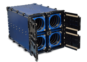 |
| QuadPack |
They have developed a four satellite container called QuadPack which holds the 4 satellites till the QuadPack is launched by the rocket and releases them later independently.
We can speculate that there may be 25 QuadPacks aboard PSLV C37 arranged around the 3 large Indian Satellites. ( A Crowdy environment .. isn't it ?? ).
BTW, ISRO is expected to recover about half of Launch Cost from these satellite operators for launching these satellites.
While we await the official document about the launch from ISRO an interesting question has been raised in one of the discussion forum:
What if one of those 88 sats are programmed to explode thus causing the loss of Cartosat & crush PSLV image in the market?
We know that any launch vehicle operator will test the satellite thoroughly before being integrated with the rocket, the possibility can't be denied totally.
What re your views? Please tell in the comments section .. I am sure it is an interesting question and we could have some lively discussion here !!


