IRNSS SYSTEM OVERVIEW :
The Indian Regional Navigation Satellite System ( IRNSS ) is an independent, ingenuously developed satellite Navigation system.
It has been fully planned, established and controlled by the Indian Space Research Organization (ISRO).
The Space Segment of IRNSS consists of 7 satellites and ( when fully configured by end 2015 ), will consist of :
The 3 satellites in Geo-synchronous Orbits ( GSOs ) parked at :
32.5º E, 83º E and 131.5º E
The remaining 4 IGSO ( Inclined Geo-synchronous Orbit ) satellites are :
with longitude crossings 55º E and 111.75º E (two in each plane).
The overall final configuration is depicted in the images below.
 |
| Ground Traces of all 7 satellites over the target area intended to be served by IRNSS |
 |
| Sequence showing 3 positions of constellation at 1 hr interval |
1. Standard Position Services (SPS), an open service without encryption
2. Restricted Service (RS), an authorized service with encryption
First, i.e. SPS service, will be accessible to anyone having a IRNSS receiver. Regular GPS receivers will not be useful to access IRNSS.
The 2nd one ( RS ) will be a special purpose high accuracy service available to classified users only.
The satellites have these signal characteristics:
Carrier frequency Bandwidth Nominal received signal strength
1176.45 MHz 24 MHz - 127 dbm
2492.028 MHz 16.5MHz - 130 dbm
As on date ( mid October 2014 ) 3 satellites have been launched and the current configuration with these satellites is shown below:

IRNSS 1A and 1B satellites ( launched in July 2013 and April 2014 respectively ) are already in their designated slot of 55º E Longitude.
As can be seen in the figure on right that the orbits of these satellites are inclined at 29 deg with equator.
The Last satellite IRNSS 1C is in Equatorial GSO and will finally be placed at 83º E.
It was launched by PSLV C26 rocket on 16th Oct 2014. What you see here is the orbit after 1st orbit raising on 17th Oct 2014.

Figure on right is the snapshot of what was seen in the figure above but as seen from a point above North pole.
Both 1A and 1B are at the same longitude hence they overlap each other. 1B being in Northern hemisphere is only seen. 1A is below it so it is not visible.
The two inclined satellites 1A and 1B are geosynchronous so they will always be on the same longitude but will oscillate N-S at that longitude making a figure of 8 in 24 hours.

This is seen in the figure on left.
The inclination of 29 degrees means the figure of 8 will span +/- 29 degrees latitudes.
Also notice that just these 3 satellites will provide 3 distinct points for triangulation for location fixing throughout day except for a very small duration when 1A and 1B are at equator. But in full configuration the other 2 similar satellites at 111.75 E will provide the other 2 points spread in two hemispheres.
Current GPS will not be able to provide 3 points throughout 24 hours with just 3 satellites.
That is the beauty of IRNSS.
Update : 18Aug2016
Now that all sats are in place here is a final overall coverage map:

But there's a catch! For location fixation we require at least four satellites to be visible. Next figure shows the approximate area which is covered almost always by at least 4 satellites simultaneously.
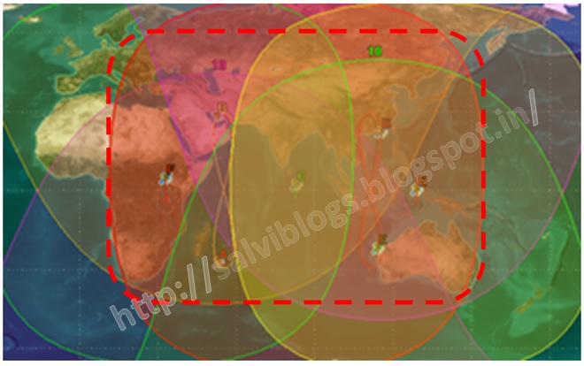 |
| The dashed RED area shows 4 satellite coverage |
No comments:
Post a Comment